Bayside is not a neighborhood you can tour with a single ticket and a map. Its landmarks sit in waterfront parks, on a working historic reservation, along quiet residential blocks, and on streets where the architecture changes every few houses. What holds them together is a long-running preservation effort, led in large part by the Bayside Historical Society, which partners with the Historic Districts Council to identify potential landmarks and landmark districts in the neighborhood.
This guide covers what is documented about Bayside’s landmarks heading into 2026: the anchors you can actually visit, the architectural styles that shape the streets, how the designation process works, the four sub-areas the neighborhood is usually divided into, and where the public record is still thin enough that you should confirm details with the people who keep it.
What Counts as a Landmark in Bayside
There are two kinds of landmarks in Bayside, and they overlap only partly. The first is the officially designated kind: individual buildings and districts that have been reviewed and protected through the city’s landmarking process. The second is the informal kind, the places residents point out to visitors and name in conversation.
The Bayside Historical Society treats landmarking as part of its core mission and advocates for more individual and district designations, both in Bayside and across Queens. That advocacy exists for a specific reason. Compared with Manhattan and Brooklyn, Queens has very few landmarks and landmark districts, and Bayside’s preservation community argues that many landmark-worthy places in the borough matter to the cultural integrity of the city as a whole.
Because designations are added over time, any list of protected Bayside properties is a snapshot. If you need to know whether a specific building is designated, the Bayside Historical Society is the right first stop.
Fort Totten and the Waterfront Edge
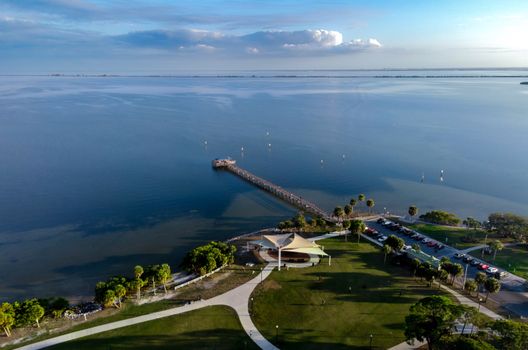
Fort Totten is the most recognizable historic anchor on Bayside’s northern edge and the name most locals reach for first. The neighborhood’s historic character is often described in relation to it. The Bay Terrace area near Fort Totten is known as a popular sunset spot, and the streets around it connect to waterfront parks and golf course shops.
Fort Totten is also the shorthand historians use for the neighborhood’s depth. As one local historical tour put it, besides Fort Totten, Bayside is filled with houses and churches of different eras and styles, which is a useful way to think about the rest of this guide.
Crocheron Park, Little Bay Park, and Clearview Golf Course
The area’s parks and waterfront promenades form a continuous greenbelt, and that greenbelt is the spine of Bayside’s open space. Crocheron Park, Little Bay Park, and the Clearview Golf Course run together as one connected stretch of waterfront and green, anchoring the eastern side of the neighborhood.
Read that greenbelt as history rather than recreation alone. Public land held along the water, with residential blocks layered behind it, is the shape of a neighborhood that grew up around its shoreline instead of paving over it. It is also the easiest part of Bayside to explore on foot, since the parks connect to each other rather than sitting as isolated pockets.
Houses and Buildings That Carry the History
Away from the water, Bayside’s landmarks are residential and religious, and they are spread across the neighborhood rather than clustered. Local photographers and walking tour organizers have documented a set of historic sites worth knowing by name, and the Bayside Historical Society maintains its own record of what has been designated and what is still under review.
Rolf Armstrong’s House, the Gingerbread Castle
Among the named historic sites in Bayside is the former house of artist Rolf Armstrong, known locally as the Gingerbread Castle. It appears on lists of Bayside historic sites and in the neighborhood’s walking tour material as one of the most distinctive residential landmarks in the area.
The nickname does a lot of the describing on its own. Since this is a private home, anyone interested in it should view it from the public street and treat residents’ privacy as the priority.
Tudor, Mediterranean Revival, Art Deco, and Streamline Moderne
Bayside’s buildings reflect the periods when its blocks were built out. The neighborhood includes a range of architectural styles characteristic of those time periods, among them Mediterranean Revival, Art Deco, and Streamline Moderne.
Tudor-style houses also appear throughout Bayside, recognizable by their steeply pitched roofs. The mix is the point: walking a few blocks in Bayside often means passing several distinct building eras in a short distance, which is why the neighborhood keeps coming up in preservation conversations.
- Mediterranean Revival, associated with one of the neighborhood’s identified architectural periods
- Art Deco, also listed among Bayside’s characteristic styles
- Streamline Moderne, the later style in the same documented grouping
- Tudor-style houses with steeply pitched roofs, spread across residential blocks
- Houses and churches from a range of eras, which local historians describe as defining Bayside beyond Fort Totten
Zagorski Farm
Zagorski Farm appears alongside the Gingerbread Castle on local lists of Bayside’s historic sites. The name points toward the neighborhood’s agricultural past, before the residential street grid that defines Bayside today was built out.
Details about the site’s current condition and public access are not consistently documented, so this is one to verify rather than assume. If you want to see it or learn more, ask the Bayside Historical Society directly before planning a trip.
How Landmarking Works in Bayside Right Now
Landmarking is not a single event. A property or district is studied, proposed, reviewed, and then either designated or left alone, and the Bayside Historical Society describes the results as lasting achievements for the people of Bayside and New York City.
The society’s current focus is expansion. It partners with the Historic Districts Council on identifying potential landmarks and landmark districts in Bayside, and it advocates for more designations locally, borough-wide, and citywide. Those success stories are framed as a platform rather than a finish line, which is the clearest signal of where preservation in Bayside is heading.
For residents, the practical takeaway is that the landmark map of Bayside is a moving target. Buildings that were not designated last year may be in review now, and districts that did not exist may be proposed next.

Bayside Gables, Bayside Hills, Bay Terrace, and Oakland Gardens
Bayside is generally described through four sub-areas: Bayside Gables, Bayside Hills, Bay Terrace, and Oakland Gardens. Each has its own character, and each contributes something different to the neighborhood’s built history.
- Bay Terrace sits closest to the waterfront edge, tied to the waterfront parks, the golf course shops, and the sunset views near Fort Totten that local guides highlight.
- Bayside Gables, Bayside Hills, and Oakland Gardens are identified as distinct Bayside sub-areas, though the sources consulted here do not break out their individual landmark histories in detail.
- Because designation status changes, check with the Bayside Historical Society for the current picture in any specific sub-area before you plan around it.
Boundaries are worth a caution too. Civic and mapping sources draw Bayside’s edges a little differently from one another, with the southern edge commonly given as 48th Avenue and the western edge as Francis Lewis Boulevard. The commercial core runs along Bell Boulevard and Northern Boulevard, which is where most visitors start and where the neighborhood’s day-to-day life is easiest to read.
Where the Name Bayside Points Elsewhere
Search for Bayside landmarks without adding Queens and you will pull up at least two other places. Portland, Maine has its own Bayside, noted for holding some of the earliest homes in that city because they escaped the Great Fire of 1866. While other Portland neighborhoods lost most of their Federal and Greek Revival architecture in that fire, Bayside suffered less damage, with most of western Bayside left untouched.
Miami also has a Bayside Historic District. None of that history belongs to Bayside, Queens, and mixing the three produces muddled results. Adding Queens to any search, or going straight to the Bayside Historical Society, keeps you inside the neighborhood you actually want to read about.

Planning a Landmark Walk in Bayside
A sensible route starts at the waterfront and works inland. Begin with the greenbelt formed by Crocheron Park, Little Bay Park, and the Clearview Golf Course, then move toward Fort Totten and the Bay Terrace edge. From there, head into the residential blocks to look at the architecture, keeping an eye out for the Tudor, Mediterranean Revival, Art Deco, and Streamline Moderne styles that show up across the neighborhood.
Walking tour material and photo archives assembled by local historians are useful for identifying specific houses in advance, though they are not a substitute for a current designation list. Two rules keep a walk respectful and accurate. Stay on public streets when a site is a private home, and confirm the status of anything you plan to write about or photograph in detail with the Bayside Historical Society, since the record changes as new landmarks are designated.
Frequently Asked Questions
What is the most famous landmark in Bayside, Queens?
Fort Totten is the anchor most people name first, and it shapes how the neighborhood’s historic identity is described. The waterfront around it, including the Bay Terrace edge known for sunset views, is closely tied to that reputation. Beyond Fort Totten, Bayside’s landmarks are mostly residential and religious buildings spread across many blocks.
Does Bayside have a designated historic district?
The Bayside Historical Society is actively working on this question. It partners with the Historic Districts Council to identify potential landmarks and landmark districts in the neighborhood, and it advocates for more designations in Bayside and across Queens, which has far fewer landmarks and districts than Manhattan or Brooklyn. Because the work is ongoing, check with the society for current status.
What architectural styles can I see in Bayside?
Bayside includes a range of styles characteristic of its different building periods, among them Mediterranean Revival, Art Deco, and Streamline Moderne. Tudor-style houses with steeply pitched roofs also appear throughout the neighborhood. Local historians describe Bayside as filled with houses and churches of different eras and styles, so a walk of several blocks often crosses more than one architectural period.
What is the Gingerbread Castle in Bayside?
The Gingerbread Castle is the local name for the former house of artist Rolf Armstrong, and it appears on Bayside historic site lists and walking tour material as one of the neighborhood’s most distinctive residential landmarks. It is a private home rather than a public attraction, so anyone interested should view it from the public street.
How can I help with landmarking in Bayside?
The most direct route is the Bayside Historical Society, which treats landmarking as part of its core mission and advocates for more individual and district designations in the neighborhood and across Queens. It also works with the Historic Districts Council to identify potential landmarks and districts, and it publishes its landmarking success stories and current priorities.